Undergraduate Courses

HIGHLIGHTS OF CHANGES IN THE UNDERGRADUATE PROGRAMME

Level 100

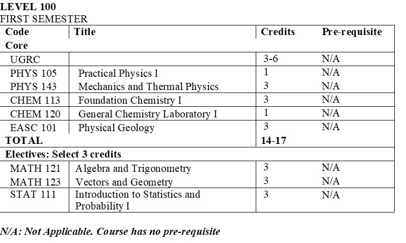
The course EASC 102: Geological Map Work has been moved to Level 200 and combined with the course on Geological Structures. The reason for the move is that most textbooks on geological structures treat these together, where the geological structures treated are related to their manifestation on geological maps. In its place, a new course, Geological Field Excursions, is introduced to present a practical way for first year students to learn about geology.


Level 200

The programme has been structured to allow Earth Science students take core courses in the Earth Sciences (mainly Geology) and electives from the basic sciences. The reason for this is that basic sciences, specifically Physics, Chemistry and Mathematics, form the foundation of any Earth Science programme.

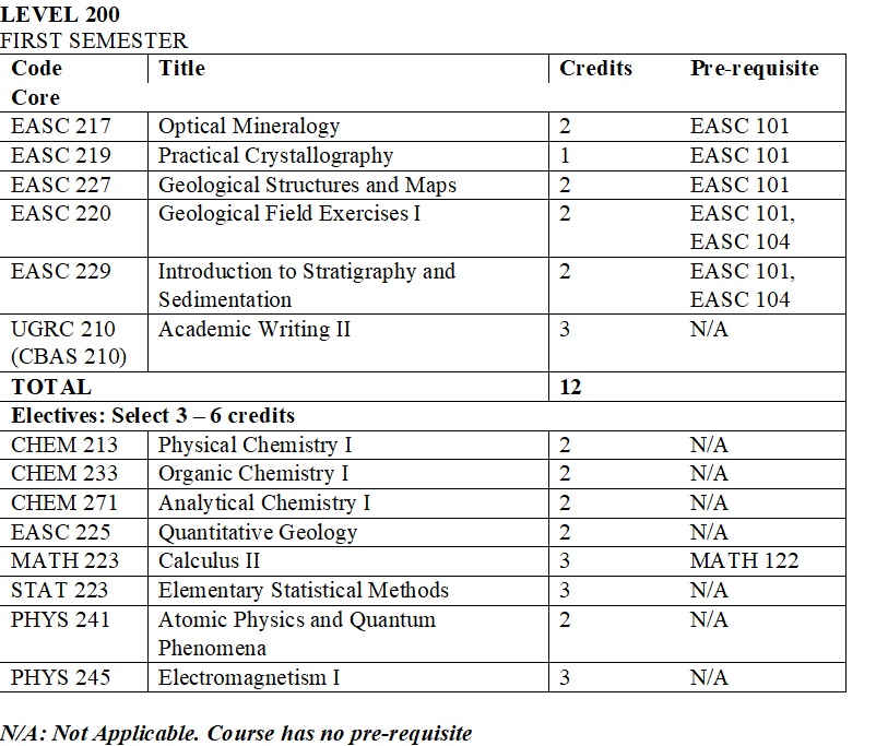
The 3-credit course Geological Field Methods I has been renamed Geological Field Exercises I and credits reduced to 2.

A course in Quantitative Geology (EASC 225) has been introduced as an elective course to introduce students to quantitative problem solving techniques in the geological sciences at the basic level. They will build on this course in the upper undergraduate levels and at the graduate level.
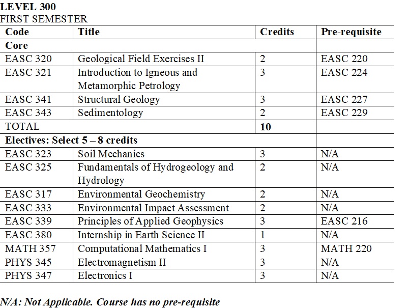
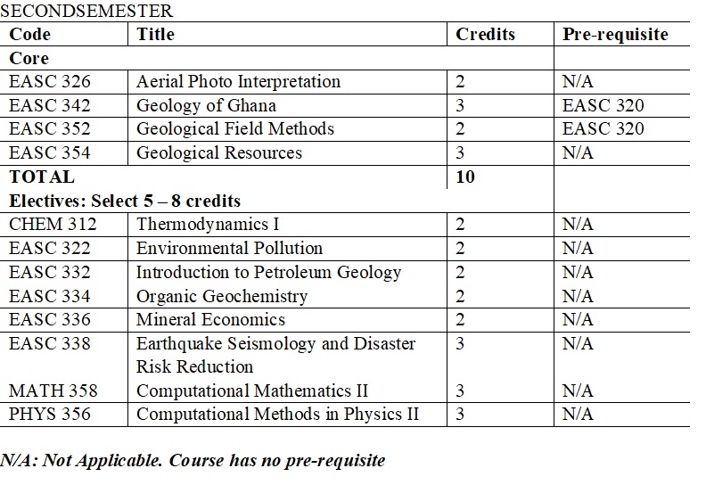
 

Level 300

At this level students take core courses mainly in Geology and take electives from applied fields such as geophysics, hydrogeology, engineering geology, petroleum geology and environmental geology.
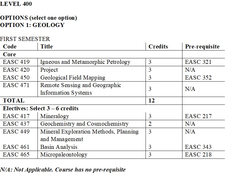
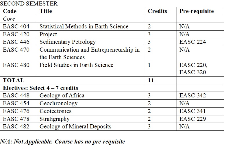
 

Level 400

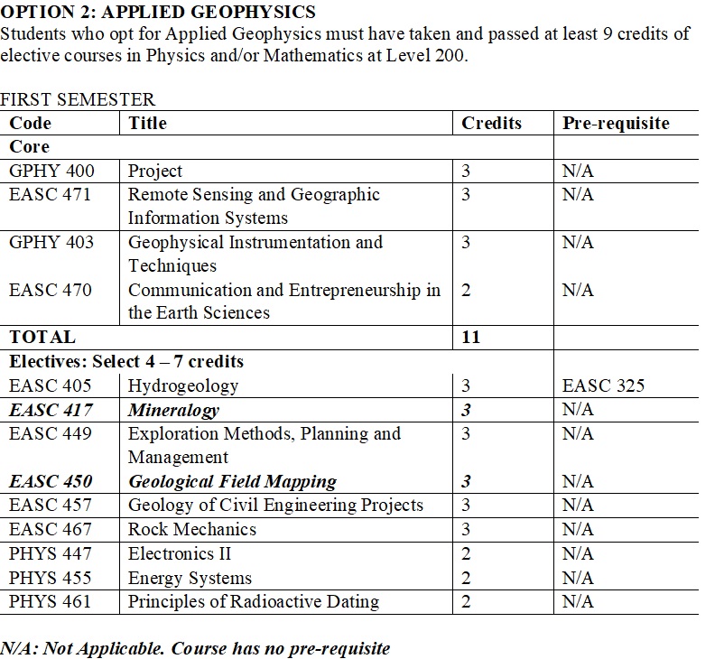
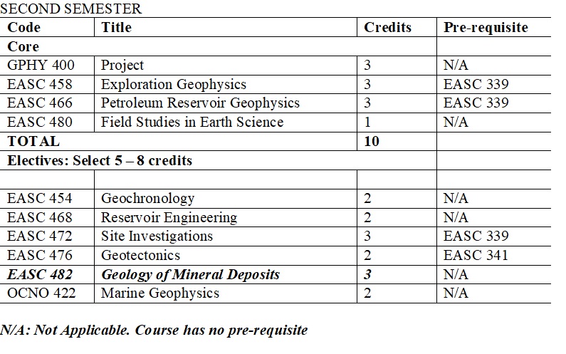
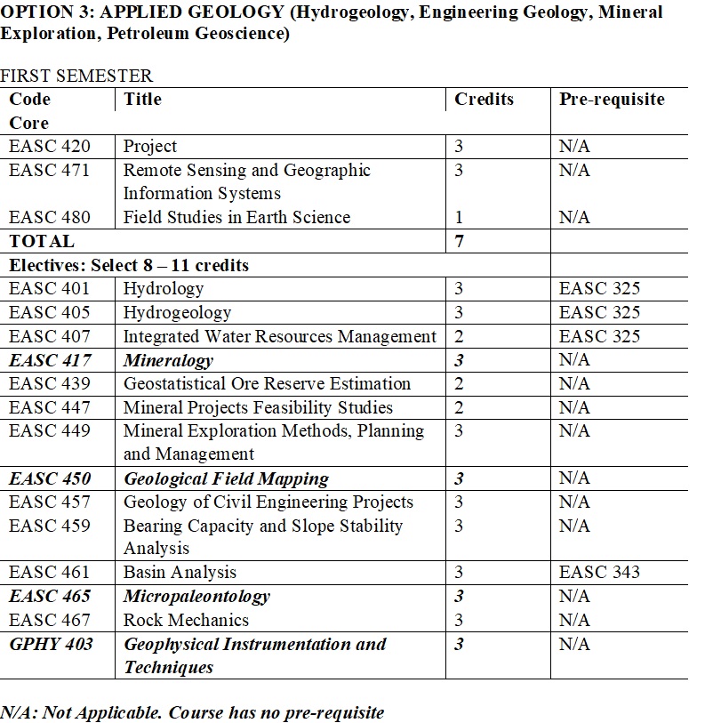
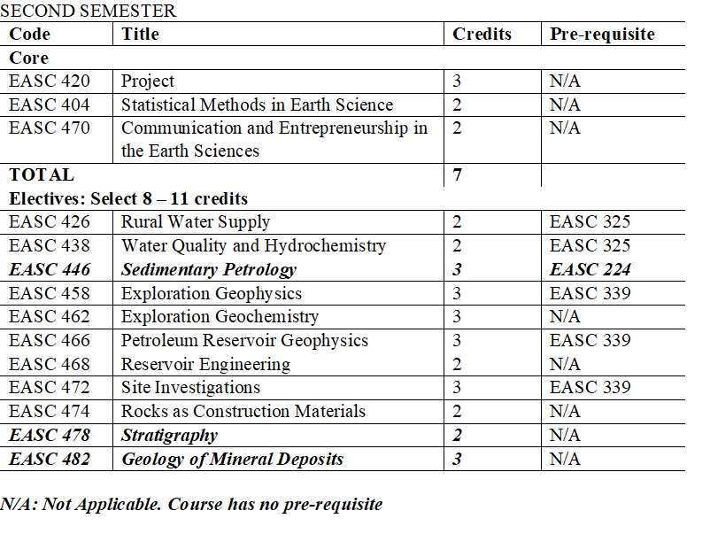
On the basis of elective courses selected at Level 300, students select a specialisation in one of these fields in the final year: Geology, Applied Geophysics, and Applied Geology. Upon successful completion of the programme students will be awarded a BSc degree in the following, depending on option selected at Level 400:

  • BSc Earth Science (Geology)
  • BSc Earth Science (Applied Geology)
  • BSc Earth Science (Applied Geophysics)


PROGRAMME STRUCTURE


SINGLE MAJOR EARTH SCIENCE DEGREE PROGRAMME

Students will be awarded a BSc degree in the following, depending on option selected at Level 400:

  • BSc Earth Science (Geology)
  • BSc Earth Science (Applied Geology)
  • BSc Earth Science (Applied Geophysics)


Course Code Title
EASC 480 Field Studies in Earth Science

Credit Hours - 1

The course includes several one-day long and one week-long field trips to hydrogeological, engineering, geoenvironmental and mine sites. It introduces practical skills appropriate to the study of earth and environmental science. The course concentrates on interactions and feedbacks in the environment, including studies of geology, landforms, soil types and water quality.

EASC 40I Hydrology

Credit Hours - 3

This course covers the following: the hydrological cycle, hydrometeorology and climate, hydrometric networks and catchment morphometry, precipitation measurements and analysis, evaporation measurements and analysis, soil moisture, river flow measurements and analysis, rainfall-runoff analysis, hydrographs. Hydrological instruments are introduced; students employ the instruments to make field measurements and perform a range of data analysis and exercises.

EASC 405 Hydrogeology

Credit Hours - 3

This course examines the exploration for groundwater resources (e.g., using geophysical methods), the development and evaluation of groundwater resources (well construction and hydraulic testing) in a variety of hydrogeological systems, and groundwater management approaches (sustainability, vulnerability). Course topics include groundwater and the hydrologic cycle, groundwater resource evaluation, well drilling methods, well screens and methods of sediment size analysis, water well design, installation and removal of screens, water well development, and well and pump maintenance and rehabilitation.

EASC 407 Integrated Water Resources Management

Credit Hours - 2

This course develops knowledge in climate dynamics, hydrology and surface water resources which actually links hydro-meteorological and hydrological processes together with the relationship between rainfall and hydrological measurements, the important of groundwater resources in water resources management. Integrated water resources management designed to provide basic understanding of the principles, paradigms and methodologies in IWRM shall be treated along with water management and the environment and water quality management and the impacts of human activities on the ecosystem. Case studies involving the major river catchments shall be carried out.

EASC 449 Mineral Exploration Methods, Planning and Management

Credit Hours - 2

The course introduces mineral exploration and mining methods. It focuses on the exploration of mineral deposits from desk studies up to harnessing of the mineral deposit. The various methods of exploration are treated in detail. Project evaluation is also discussed. The course covers the following topics: exploration programme design, reconnaissance exploration, detailed or follow-up exploration, sampling and assaying techniques, drilling techniques, project evaluation.

EASC 447 Mineral Projects Feasibility Studies

Credit Hours - 2

A mining feasibility study is an evaluation of a proposed mining project to determine whether the mineral resource can be mined economically. This course deals with the basic concepts of feasibility studies, including important aspects and stages. Course content: The role of the feasibility study in the mine development decision process, organization of the preliminary feasibility study, presentation of project material, mining methods, geological data, mineral processing, surface facilities/ infrastructure/environmental requirements, capital and operating cost, revenue estimation, mineral taxation and financial evaluation, sensitivity and risk analysis.

EASC 439 Geostatistical Ore Reserve Estimation

Credit Hours - 2

This course will present basic concepts of geostatistics and ore reserve estimation. It will treat the data requirements for optimal geospatial modelling, data distributions, and the univariate statistical tools that are applicable to the preliminary assessment of data prior to geospatial modelling. The course will treat the various sampling techniques that are commonly used to acquire data for modelling and discuss their weaknesses and strengths. The traditional estimation methods will then be treated with practical demonstrations of their strengths and weaknesses. The course will then proceed to treat spatial continuity modelling. The course will expend significant part of the session to discuss the relevance of spatial continuity modelling, the types of theoretical variogram models commonly used, and the concept of structural analysis. Ordinary kriging will be treated, along with the concepts of geological modelling, and resource estimation. Students will be introduced to multivariate kriging, and non-linear estimation techniques.

EASC 457 Rock Mechanics

Credit Hours - 3

The course will cover urban geology, engineering geology of dams and tunnels, building cracks evaluation, and ground treatment. It will also consider the role of engineering geologist during construction of roads, houses, dams, tunnels, etc. In-depth study using case studies of major civil engineering projects such as tunnels, motorways, dams, etc., will also be covered. The course may include visits to mine sites.

EASC 459 Bearing Capacity and Slope Stability Analysis

Credit Hours - 3

Theory of bearing capacity cohesive and cohesionless soils and clays; Bearing capacity estimation from in situ tests; Estimation of bearing pressures by empirical methods, Foundation Types; Protection of foundations against attack by soils and groundwater. Slope failure types in soils, General methods of analysis in cohesive and cohesionless soils, End-of-construction and long-term stability. Plane failures; Wedge failure; Circular failure; Toppling failure; Application of Hemispherical Projections to Determine Failure Modes; Influence of a slope curvature upon stability; Surface protection of slopes; Control of rock falls; Monitoring and interpretation of slope displacements. The course will also include a three-day field visit.

EASC 467 Geology of Civil Engineering Projects

Credit Hours - 3

Index properties of rocks; engineering characteristics of rocks. Shear strength of planar discontinuities; Shearing on an inclined plane; Surface roughness; Shear testing on discontinuities in rocks; Estimating joint compressive strength and friction angle; Shear strength of filled discontinuities and closely jointed rock masses; Residual Strength; Schmidt Hammer Test. Rock Mass Classification and their importance in engineering works; Rock Quality Designation; Influence of clay seams and fault gouge; CSIR classification of jointed rock masses; NGI Tunneling Quality Index. Types of earth-moving equipment; Borrow materials; Cuts in rocks and soils; Foundations; Free-draining materials; Roads and Highways; Earth dams; Canal works. Laboratory work.

EASC 46I Basin Analysis

Credit Hours - 3

This course focuses on the different kinds of sedimentary basins, the processes that form these basins, the processes that bring about filling of basins, and the nature of the fills. The methods used to carry out basin analysis and the applications of basin analysis are also discussed. Topics to be discussed include physical state of lithosphere, mechanisms of sedimentary basin formation by stretching, strike-slip, flexure and compression, effects of mantle dynamics, basin infill mechanisms and depositional systems, subsidence and thermal history, basin mapping methods, and application to the petroleum system, leading towards the play concept.

EASC 426 Rural Water Supply

Credit Hours - 2

The course is designed to incorporate various areas in water resources management including water as a resource, water resources of Ghana, Ghana’s water policy, water supply options in Ghana; management, planning and implementation of rural water schemes. Basic principles and concepts in rural water supply, community interactions, developing a project strategy; Community Water supply policy of Ghana will also be taught. Topics such as finding, design, constructing and assessing groundwater, water quality aspects of rural water supply; rural water infrastructure, capacity building, community water supply options and innovations will also be taught. Case histories will be an integral part of the programme.

EASC 438 Water Quality and Hydrochemistry

Credit Hours - 2

This course deals with water quality studies and sources, behavior and transport of contaminants. There is particular focus on interactions between water and minerals and their significance for groundwater composition. Course content include: water quality standards; hydrochemical behaviour of contaminants; measurement of parameters; hydrochemical sequences; graphical methods and hydrochemical facies; sources of contaminants; contaminant transport; hydrochemical behaviour of contaminants.

EASC 458 Exploration Geophysics

Credit Hours - 3

This course builds on EASC 335 and deals with geophysical techniques applied to solving geoscience problems with focus on techniques relevant to the exploration for groundwater and mineral resources: seismic, electrical (resistivity, S.P. & I.P.), electromagnetic, gravity, and magnetic methods. The course is intended to be practical, hands-on, and field-oriented so applications are emphasized, and theory is kept to the minimum. Case studies are included to illustrate applications. Hands-on experience at working with data is provided through laboratory exercises and take-home assignments.

EASC 462 Exploration Geochem istry

Credit Hours - 3

The course focuses on the application of geochemistry to mineral exploration. Topics discussed include the following: geochemistry of the supergene environment; supergene mineralization; regolith geochemistry; geochemical survey methods (lithogeochemical, stream sediments, soil, hydrogeochemical, geobotanical, biogeochemical); statistical treatment of geochemical data; analytical methods. Modern developments in understanding geochemical and isotopic systems and techniques applied to mineral exploration will also be discussed.

EASC 466 Petroleum Reservoir Geophysics

Credit Hours - 3

The applications of geophysics in 2D and 3D mapping of geological structures. Reflection seismic acquisition. Seismic processing fundamentals and digital filtering. Interpretation of 2D and 3D seismic reflection data, including horizontal and vertical slices, presentation parameters, horizon autotracking, fault mapping, stratigraphic and structural interpretation, and reservoir evaluation. Reservoir aspects of seismic interpretation. Seismic stratigraphy.

EASC 468 Reservoir Engineering

Credit Hours - 2

The course covers basic petrophysical properties of reservoir rocks including porosity, permeability, fluid saturation, electrical conductivity, capillary pressure, and relative permeability; classification of oil and natural gas reservoirs; introduction to reserve estimation principles. Laboratory measurement of the reservoir rock characteristics mentioned above. Derivation of the general material balance equation. Application of the general material balance equation for determining initial oil in place and gas cap size and water influx constant under different drive mechanisms. Application of the general material balance equation for determining the initial gas in place for conventional gas reservoir.

EASC 472 Site Investigations

Credit Hours - 3

Covers site mapping, test pit excavations and logs, drilling methods and equipment, disturbed and undisturbed sampling, water sampling, in-situ tests, exploratory drifts and tunnels, and installation of piezometers. It also covers the application of geophysical surveys in site investigations, and the interpretation of geophysical survey results and implications on engineering geological problems. Students are also taught how to prepare site investigation reports. Case studies are discussed in class. The course may include field visits.

EASC 474 Rock as Construction Materials

Credit Hours - 2

The course deals with explorations for quarries and rock aggregates for concrete, roads and highways, runways and railways. It also considers explosives and blasting, physical properties and chemical reaction on aggregates in concrete mixes, sulphides and organic substances in concrete, and pozzolanic materials. The techniques in sampling and laboratory analyses of samples are also considered. The course includes field visits to quarries and construction sites.

EASC 482 Geology of Mineral Deposits

Credit Hours - 3

The course gives an overview of the main types of metallic and non-metallic mineral deposits, their geological environments, geochemistry, mineralogy, structural geology and genetic constraints. It also considers the chemical, petrological, structural, and sedimentological processes that contribute to ore formation. Contents include: Distribution of economic mineral deposits with respect to their plate tectonic setting, lithological-stratigraphical environments, mineralogy, geochemistry, morphology and structural features. Description of classic deposits representing individual deposit types. Review of exploration strategies. Laboratory classes consists of hand specimen study of host rock-ore mineral suites and reflected light microscopy.

EASC 478 Stratigraphy

Credit Hours - 2

This course involves the large scale vertical and lateral relationships between units of sedimentary rock that are defined on the basis of lithologic properties, paleontological characteristics, geophysical properties, age relationships, and geographic position and distribution. The course is divided into three parts. Part I deals with lithostratigaphy and considers vertical and lateral successions of strata and correlation of lithostatigraphic units. Part II deals with fundamental principles, and methods and applications of sequence stratigraphy. Part III deals with biostratigraphy, the characterization and correlation of rock units on the basis of their fossil contents

EASC 476 Geotectonics

Credit Hours - 2

Covers the origin and history of major tectonic forms and features of the earth, and their interaction and evolution through time. It examines modern tectonic principles and fundamental tectonic forms and textures of the earth’s lithosphere and crust - orogenic belts, cratons, island arcs, rift zones, continental margins, etc, and discusses geotectonic models emphasizing on modern plate tectonic concepts. A knowledge of structural geology is required

EASC 454 Geochronology

Credit Hours - 2

The primary objective of this course is to provide a practical overview of principles and techniques used in geochronology. The theory, methodology and interpretation of the following dating techniques will be discussed: UTh-Pb, Rb-Sr, Sm-Nd, Pb-Pb, K-Ar, Ar-Ar, and Fission track dating. Cosmogenic and fossil isotopes. The dating of Ghanaian rocks will also be discussed.

EASC 448 Geology of Africa

Credit Hours - 3

This course is designed to introduce the student to the regional geology of Africa, the major geological events that have shaped the continent, mineral resources of Africa as well as the evolutional history of Africa. The main focus of the course is a discussion on the major tectonic events that consolidated the continent and the timelines, the resulting mineralisation and the compositions of the different cratons in Africa. The course covers the following topics: Precambrian Geology of Africa, Proterozoic cratonic basins and mobile belts, Palaeozoic sedimentary basins in Africa, Mesozoic – Cenozoic basins in Africa, the Atlas Belt.

EASC 446 Sedimentary Petrology

Credit Hours - 3

This course gives a broad understanding of the petrology of sedimentary rocks. The course consists of two parts. Part I deals with siliciclastic sedimentary rocks by examining the characteristics features of sandstones, conglomerates, shales and mudrocks. The important topic of sediment provenance is discussed followed by discussion of diagenesis of siliciclastic sedimentary rocks. Part II deals with chemical/biochemical sedimentary rocks. It describes limestones, discusses dolomites and examines the diagenesis of these carbonate rocks. It then describes the characteristics of evaporites, cherts, phosphorites, and iron-rich sedimentary rocks and discusses some of the controversial aspects of their origin

EASC 470 Communication and Entrepreneurship in the Earth Sciences

Credit Hours - 2

The course is divided into two parts. The purpose of Part I is to help students to communicate ideas better and to learn the skills of communicating geoscience. Topics include discussion and review of different kinds of geological publications. Also included are oral presentation delivery, proposal development, and content organization. Part II teaches students the basic and foundational skills needed to start their own business in the geoscience industries. Using the fundamentals of economics, marketing, accounting, and business organizations, students will develop a comprehensive business plan that includes sales, financial, and legal considerations for starting and operating a small or medium scale business.

EASC 480 Field Studies in Earth Science

Credit Hours - 1

The course includes several one-day long and one week-long field trips to hydrogeological, engineering, geoenvironmental and mine sites. It introduces practical skills appropriate to the study of earth and environmental science. The course concentrates on interactions and feedbacks in the environment, including studies of geology, landforms, soil types and water quality.

EASC 404 Statistical Methods in Earth Science

Credit Hours - 2

This course covers the techniques of probability and data analysis as applied to problems in the earth and environmental sciences. Topics include probability, data description, hypothesis testing, time series analysis, correlation and regression analyses, and multivariate methods. Laboratory work focuses on the use of statistical software packages for data analysis.

EASC 46I Basin Analysis

Credit Hours - 3

This course focuses on the different kinds of sedimentary basins, the processes that form these basins, the processes that bring about filling of basins, and the nature of the fills. The methods used to carry out basin analysis and the applications of basin analysis are also discussed. Topics to be discussed include physical state of lithosphere, mechanisms of sedimentary basin formation by stretching, strike-slip, flexure and compression, effects of mantle dynamics, basin infill mechanisms and depositional systems, subsidence and thermal history, basin mapping methods, and application to the petroleum system, leading towards the play concept.

EASC 465 Micropaleontology

Credit Hours - 3

The course gives a presentation of the various microfossil groups by discussing their morphology, taxonomy, mode of life, environments and stratigraphic distribution. Emphasis is laid on groups of geological importance by elucidating their application for dating, correlation and facies interpretation of sedimentary successions. The microfossils covered in class include foraminifera, ostracods, conodonts, and diatoms. It will also cover pollen and spores, dinoflagellates, acritarchs. Some applications of palynology will also be discussed. Practical work will include the method of preparation of microfossil.

EASC 437 Geochemistry and Cosmochemistry

Credit Hours - 2

This course discusses the Earth from geochemical perspective, using the fundamental geochemical tools studied in EASC 214. It covers the following: Cosmochemistry: nucleosynthesis, meteorites, formation of the solar system and the planets; The Mantle and Core of the Earth: composition of the earth’s mantle and core, the “primitive mantle”, magma ocean and mantle differentiation, mantle geochemical reservoirs; The crust of the Earth: oceanic crust; crust-mantle interaction, continental crust, growth of the continental crust; Reactions at the earth’s surface: weathering, soils, and stream chemistry; The oceans as a chemical system.

EASC 4I7 Mineralogy

Credit Hours - 3

The course is divided into two parts. Part 1 comprises crystal chemistry, crystal growth, relationship between crystal structure and temperature, pressure, and composition (phase equilibria), x-ray crystallography and chemical analysis of minerals. Part 2 concerns detailed study of selected phase systems, systematic and determinative mineralogy and analysis of some selected minerals.

EASC 450 Geological Field Mapping

Credit Hours - 3

This course is designed to train students in field mapping techniques and related skills. Skills developed during field camp typically include: field surveying, collection of geological data, construction of measured sections, interpretation of geological structures and how to take data, samples, and notes in the field. Students spend 3-4 weeks in the field during the long vacation, to collect geological data, analyse and interpret the data, and prepare geological maps and cross sections. Students work in groups in the field but work independently on the data gathered. At the end of the course, students present a report on the geology of the studied area.

Reading list: 

Coe, A. L. (2017). Geological Field Techniques (1st Edition). Wiley-Blackwell 

Compton, R. R. (1985). Geology in the Field. John Wiley & Sons, NY.

Lisle, R. J., Brabham, P., & Barnes, .1. W. (201 l). Basic Geological Mapping (Geological Field Guide) (5th Edition). John Wiley & Sons. 

Moseley, F. (1981). Methods in Field Geology. W. H. Freeman & Co, Oxford, 

Tucker, M. E, (1982). Field Description of Sedimentary Rocks (Geological Society of London handbook series) (1"t Edition). John Wiley & Sons

EASC 47I Remote Sensing and Geographic Information Systems

Credit Hours - 3

This course is of two parts. Part I introduces the principles and concepts of Remote Sensing (RS). In this part, students are introduced to environmental issues of the Earth, principles of RS, satellites and sensors, RS imagery, data acquisition systems, digital image processing for RS imagery, and applications. Part II introduces the principles, concepts and applications of Geographic Information Systems (GIS). Database development, manipulation and spatial analysis techniques for information generation will be taught. Application of GIS in natural resource management, environment, civil engineering, etc, will be discussed through mini project and laboratory exercises.


Reading List 

  • Bhatta, B. (201l). Remote Sensing and GIS. Oxford University Press Incorporated. 
  • Campbell, J.B, (2008). Introduction to Remote Sensing (4th Edition). Guiltford Publications. 
  • Chipman, J.W., Lillesand, T.M., & Kiefer, R.W. (2003). Remote Sensing and Image Interpretation. Wiley & Sons Incorporated. 
  • Jensen, J.R. (2006). Remote Sensing of the Environment: An Earth Resource Perspective. Prentice Hall. 
  • Lillesand, T., Kiefer, R.W., & Chipman, J. (2015). Remote Sensing and image interpretations. Wiley & Sons Incorporated.